Change Detection: Eyes on Everything for Faster, Smarter Crisis Management
Change Detection: Eyes on Everything for Faster, Smarter Crisis Management
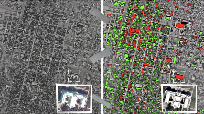
Visual inspection of the estimated damage detection map following the 2010 earthquake in Haiti: The satellite image on the left displays a specific area before the earthquake and the image on the right displays the same area analyzing the damaged (red) and non-damaged (green) buildings after the earthquake. The zoomed in imagery are of The National Palace of Haiti.
Image Credit: Umut Karabacak - Terris Earth Intelligence Inc.
Change detection has the power to help map a safe path through chaos and crises. That’s the power machine learning brings to earth observation and its potential is immense.
We’ve all seen those ‘before’ and ‘after’ photos of what a place looks like where disaster has struck. How tall the buildings were, how wide the boulevards, how deep and diverse the forests and how pristine the beaches.
Imagine if you could see that difference if all you had was the ‘after’ image. You could quickly assess where the greatest degree of damage was located, where lives were most gravely in danger and how to safely map a rescue route for first responders.
I don’t have to imagine it because that’s what I create.
In the last few years there has been a massive surge in the number of commercial satellites circling the earth. Those satellites, along with airplanes and unmanned aerial vehicles, otherwise known as drones, are collecting millions of pixels of data from every place on earth. Add to that the data explosion on the ground via street-view images, mobile mapping data, and soon, self-driving cars, and the public and private sector now has ready access to visual data that was once the sole property of national governments and militaries.
There’s so much earth observation data now that geospatial data overlaps, giving us incredibly accurate and detailed images of areas that were only a few years ago considered remote and not well understood.
Now, not only can we see up-to-date images of these areas, we can mix and merge the data to detect changes in just about anything happening on the ground. Changes in vegetation, terrain, development, erosion, and human activity, both the legal and illegal kinds.
To date, the greatest impact of change detection technology has happened around emergency response and natural disasters.
For instance, through my research at the University of New Brunswick I and my colleagues were able to access satellite images following the Beirut port explosion in August 2020 and the 2010 Haitian earthquake. We applied artificial intelligence and machine learning to map what those areas had looked like – where the buildings had stood, where the roads had connected – and predict with better than 90 percent accuracy where first responders should focus their efforts and the most efficient and safest routes to reach the most damaged areas.
With the 2010 Haitian earthquake response as our baseline, we were able to re-train the AI to design a model to analyze the 2018 Woolsey Fire, which destroyed close to 97,000 acres of California in Los Angeles and Ventura Counties and forced the evacuation of 295,000 people. All we had to work with were drone images, which provided data for about 20 percent of the total area. Our change detection AI and machine learning filled in the rest – and achieved 98 percent accuracy of the whole picture.
Powerful technology that will save lives, save land and save investments, whether they are the family home or a large industrial site.
Technology that trains machines to think, to see what people can’t, so together we can make faster, smarter decisions.
That’s change detection: bringing the world to our desktops so we can map a safe and secure way forward.